War made the Waioeka Gorge notorious, but the scenic road through it has made it a drawcard for motorists. Hugh de Lacy tells its story.
It says much about the ruggedness and inaccessibility of the Waioeka Gorge that it was where Te Kooti took refuge after the massacre that attended his losing the battle of Ngatapa, and that a decent road through it was not completed until 1962.
Today the main route from Poverty Bay and Gisborne through to Opotiki and the Bay of Plenty, the Waioeka Scenic Highway is one of the country’s most stunning drives, but the gorge and the river from which it takes its name presented massive obstacles to Te Kooti’s pursuers and road-builders alike.
The Waioeka River rises in the Huiarau Range and flows north to discharge into the sea at Opotiki, on the way plunging for 25 kilometres through a mostly vertical-walled gorge.
After his escape on the captured ship Rifleman from his detention on the Chatham Islands, Ringatu Church founder Te Kooti had ended up taking refuge in the Waioeka, only to be eventually dislodged and driven deeper into the Urewera country in a combined government and Maori campaign that saw massacres inflicted by both sides.
Te Kooti was eventually given protection by the Waikato king Tawhiao and later pardoned by the government, but meanwhile the Waioeka served as a bolthole for disaffected Maori battling the land confiscations of 1863.
Settlers were attacked all along the Bay of Plenty coast, and the missionary Carl Volkner was murdered at Opotiki in 1865.
In response, the Armed Constabulary pushed a road south from Opotiki and some distance up the river in the 1870s, and as the fighting waned settlers moved in to farm, albeit with mixed success.
The military road remained the main incursion into the Waioeka Valley until 1913 when, following a deviation through the Motu River valley, it began to be pushed south towards Matawai.
At about this time there was a plan to link Palmerston North with Hamilton by way of a railway through from Gisborne to Opotiki.
Launched from both directions, it got as far as Motu in the south and Taneatua in the north – barely 50 kilometres apart – but at that point it was abandoned in favour of a road connection through the Waioeka.
Local settlers petitioned the then Minister of Works, Gordon Coates, in 1920 to push the road through, and bit by bit over the next decade it was, with a service car being the first to complete the journey between Opotiki and Gisborne by way of the Waioeka in 1929.
But to call it a road by today’s standards is stretching the definition: it was little more than an unsealed bullock-and-dray track, crossing countless unbridged streams that became impassable in wet weather, manoeuvring round bends tighter than a hairpin, and clinging to sheer cliffs of mud and greywacke that dumped landslides on it at every rainfall.
The road’s primary use was for stock driven from Poverty Bay through to the markets and exporters of the Waikato and Auckland, but it proved a magnetic challenge to the owners of early motorcars.
Head-on collisions on the endless succession of blind bends were frequent, though they seldom did much damage because the vehicles were forced to go so slowly anyway.
Though crude in the extreme, the road did feature a couple of notable bridges.
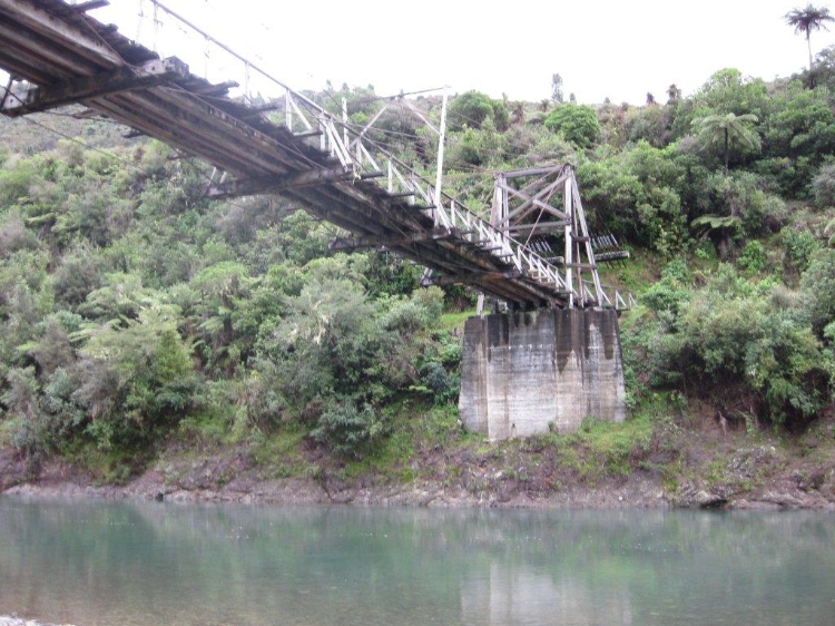
A harp construction bridge, one of only two such bridges still standing in New Zealand, was built at the north end of the gorge in 1921 to give access to families farming up the Tauranga Valley, replacing an earlier wooden bridge that had been swept away in floods in 1918.
Designed by the Public Works Department and built for the Opotiki County Council using Australian hardwood, it has a single span of 58 metres with two gantry-style towers, each supporting six steel cables. It has been registered by the NZ Historic Places Trust as a Category 1 historic place.
Not far away is the Manganuku Bridge, built over a tributary of the Waioeka, and comprising a 9.5 metre land-span of rolled steel joists, and a modified Howe truss span of 25 metres sitting on a concrete pier and abutments.
Despite its perils, the single-lane road continued to attract increasing amounts of traffic and demands for it to be upgraded, but the Great Depression of the 1930s and World War Two that followed it precluded any major investment at the time.
That all changed with the prosperity that followed the war, and in 1950, as the Korean War generated the last great boom in wool prices, the Government announced it was going to upgrade the Waioeka route to a six metres wide two-lane sealed highway – never mind the cost.
And what a cost it proved to be: the 25-mile (40 kilometre) stretch through the gorge from Trafford’s Hill at the north end cost £2 an inch ($4 per 2.5 centimetres) or £120,000 a mile ($150,000/kilometre).
Typical of the engineering challenges was that posed by Maori Bluff, a 50 metre high cliff that had to be dropped into the river, and the river itself moved over 12 metres through solid rock, to make room for the carriageway.
Blasting brought the cliff down, but to clear the debris for the road proper, bulldozers were lowered down the cliff-face on steel ropes.
It was as hair-raising a bit of earthmoving as was ever performed in this country.
The drivers were mostly from the local Ngati Ira iwi, and three of them – Hau Coleman, George Kahika and Puhi Campbell – lost their lives in the construction.
They are remembered by their names being on a plaque at Wairata Junction, 50 kilometres south of Opotiki, which was unveiled on December 15 1962 by William Goosman, the Minister of Works in the Holland and Holyoake governments, to mark the completion of the road widening.
“They say that if you give the engineers enough money they will do anything,” Goosman told the 400 attendees at the rain-drenched unveiling.
“We have given them the money and they have done it.”
Because of their contribution to the road’s construction, no less than their role on both sides of the bloody battles in the Waioeka Gorge, Maori played a prominent part at the ceremony.
Local kaumatua P. Baker praised the three “who fell during the performance of their duty”.
“We all feel that they, together with their co-workers, have carved out of impossibility a road – a fine and beautiful road – in this notorious and dreadful Waioeka Gorge,” Baker said.
Since 2004 the road has been subject to steady improvement, with engineering and signage upgrades, and the establishment of seven rest areas for motorists to view the scenery, and learn about the gorge’s history from plaques provided by the Department of Conservation.
The result is a road through an area that is no longer “notorious and dreadful”, but a monument to an extraordinary construction achievement in an area as beautiful as any to be found in the country.